Starting alongside the Exe Estuary in Exmouth this route climbs through the historic village of Woodbury and up to Woodbury Castle Iron Age hillfort on Woodbury Common.
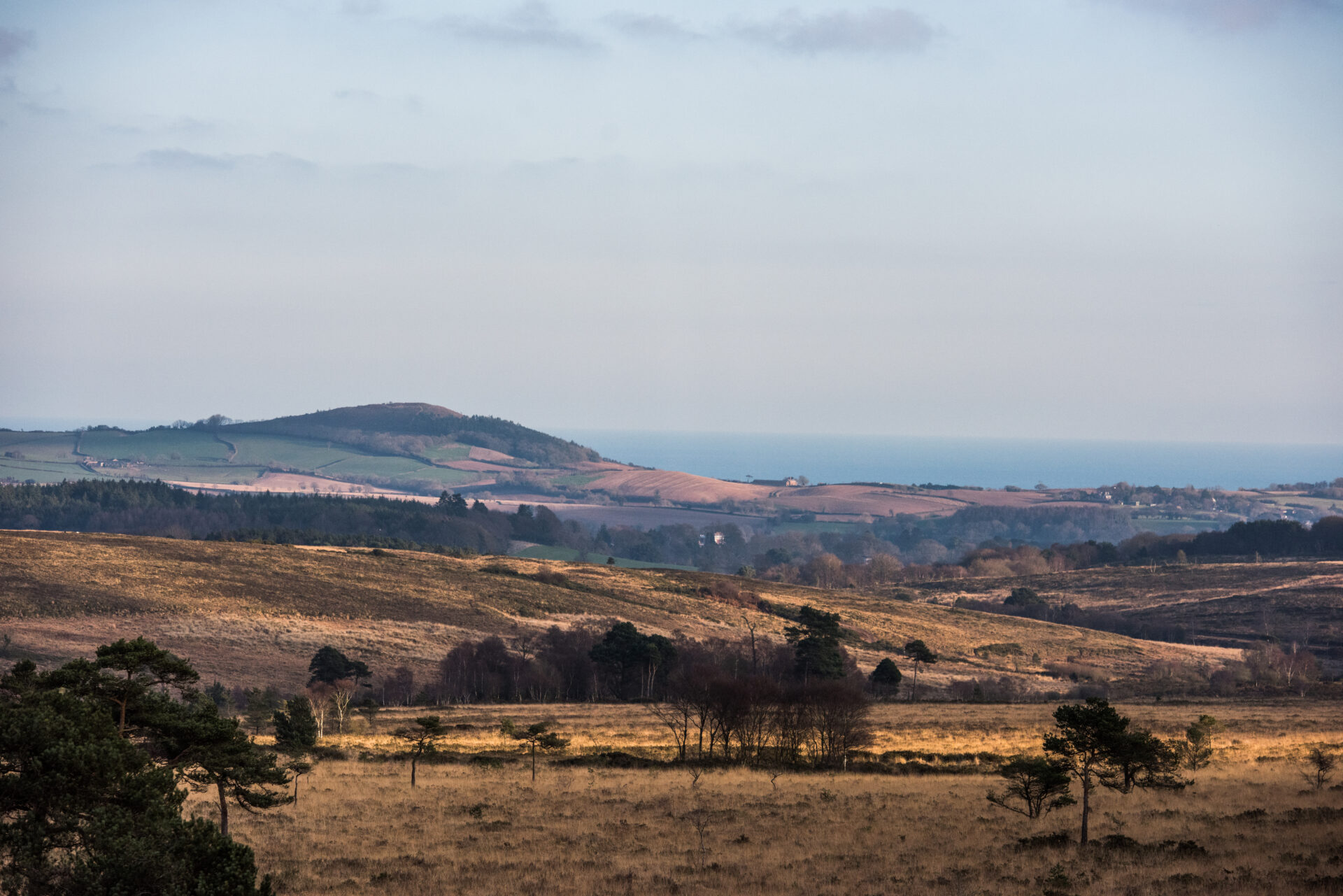
With stunning views out over the Exe Estuary and the chance to get up close and watch a wide range of water birds and explore the Pebblebed Heaths it’s a great year round route.
Additional Information
Exmouth, with its two miles of golden sandy beaches, is one of Devon’s oldest seaside resorts. It has the longest seafront promenade in the county and was established in the 18th century. The opening of the railway in 1861 made visiting the area much easier and the town remains popular to this day with visitors and watersports enthusiasts.
Woodbury was the final home of William Keble Martin, who wrote the Concise British Flora. Published when the author was 88, the book was the result of a lifetime’s work painting and describing hundreds of plant species and was an immediate bestseller.
Woodbury Common is part of the Pebblebed Heaths. The heathland area was created by Neolithic farmers around 4000 BC when they started clearing the area of deciduous woodland to create pasture for their animals. Further clearance, grazing and burning over the centuries created the heathland.
designed for the Royal Household and can be found in luxury houses around the world.
Trinity Hill has the remains of 17th century beacon and beacon house near the highest point. Although there is no longer evidence of the beacon house above ground, the Scheduled Monument with its low flat-topped earth bank and surrounding ditch can still be seen. It is thought to be an unusual and relatively late type of beacon and an important part of the coastal defences at the time.
Directions
1 - 5. Starting alongside the estuary at the edge of the Imperial Road Car Park...
…head north with the estuary on your left.
2. Go through a wooden kissing gate and follow the footpath alongside the estuary and around to the right to cross the railway.
3. Cross the railway and turn left in the park on the other side. Follow the tarmac path out through a gap to Carter Avenue.
4. Turn left and follow the road over the bridge and around to the left.
5.
Continue straight on along the Exe Estuary Trail. After approximately 545 yards/500 metres turn left onto a footpath.
This footpath is very narrow in places. If you would prefer a wider route continue on the Exe Estuary Trail. The two routes eventually converge again.
6 - 10. Follow the footpath alongside the railway to a crossing.
TAKE CARE crossing the railway to a grassy area alongside the estuary. Follow the footpath around to the right through the open area and on along a narrow path beside the estuary. There are stunning views out across the water along this stretch, but it is very narrow in places.
7. Follow the footpath until it comes out through a narrow gap onto a Sowden Lane.
8. Turn left along the lane and follow it past the benches overlooking the estuary and uphill into Lympstone.
9. Continue through Lympstone village and turn left just before the railway bridge. Follow the Exe Estuary Trail uphill past the station and around to the right over the railway.
10. After the railway bridge turn left and continue to follow the Exe Estuary Trail to Station Road in Exton.
11 - 15. Turn right along Station Road...
…and follow it around to the right and then left to a cross roads.
12. TAKE CARE and use the pedestrian crossing to cross the A376 into Mill Lane. Follow the lane for a short distance.
13. TAKE CARE and use the pedestrian crossing to cross the A376 into Mill Lane. Follow the lane for a short distance.
14. Follow the footpath straight on going through another metal kissing gate to a footbridge on the right.
15. Cross the footbridge and turn left. Follow the hedge on your left going through another metal kissing gate and continuing to a gated footbridge.
16 - 20. Cross the footbridge and head diagonally right...
…to go through a metal kissing gate and follow the hedge on the left to another footbridge.
17. Cross the footbridge and go straight across the quiet Rydon Lane. Go through a metal kissing gate onto another footpath and go straight on across the field to follow the hedge on your left to a track.
18. Go through the gate and follow the track until it turns into a tarmac road. Continue straight on past a car breakers to a T-junction.
19. Turn left along Gilbrook TAKING CARE along the narrow section over the bridge. Continue straight on to the crossroads.
20. Turn right along the pavement along Broadway to the pedestrian crossing. TAKE CARE as you cross and turn left and then right into Greenway.
21 - 25. Follow Greenway through Woodbury ignoring all side turnings...
…until it turns into Parsonage Way. Follow it to the edge of the village and turn right into Cottles Lane.
22. Follow Cottles Lane up to a T-junction.
23. Turn left up Castle Lane and follow it for a short distance before turning right through a gate onto a bridleway opposite the last house.
24. Follow the bridleway along a grass lane and out through a gate into fields. Turn left and follow the hedge on your left to a gate into woodland.
25. Go through the gate and follow the grassy track across a stream and straight on to join a stony track. Continue uphill to a junction of tracks.
26 - 27. Go around the metal barrier and diagonally right across the track.
At the next track junction turn left. Follow the track uphill and around the side of another metal barrier to reach a main road.
27. TAKE CARE crossing the B3180 to reach Woodbury Castle Car Park where you can join the East Devon Way.
From here you can:
Turn right to follow the East Devon Way west to the South West Coast Path and Exmouth seafront.
Turn left (towards Woodbury Castle) to follow the East Devon east towards Newton Poppleford and eventually Lyme Regis.
This route was originally developed by James Baldwin and checked by Ted Swan. It was reviewed and updated in 2026.