


Starting on the edge of the Exe Estuary in Exmouth, this section of the route follows the South West Coast Path along the seafront and out to Sandy Bay.
From here it continues along paths and minor roads to follow the Exmouth to Budleigh Salterton Cycleway east before turning north up over Dalditch Common and alongside Squabmoor Reservoir to East Budleigh Common.
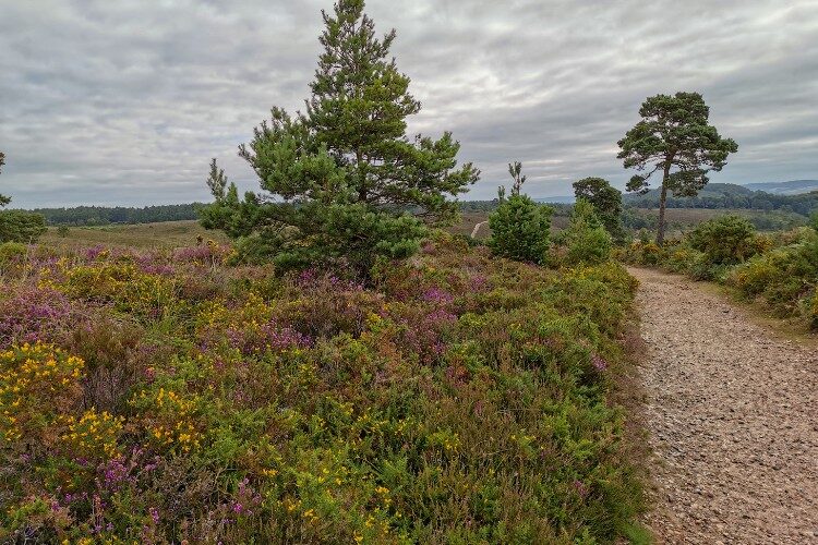
The route then sweeps past the disused Black Hill Quarry andacross the commons of Bicton and Woodbury to the 2,500-year-old Iron Age hillfort of Woodbury Castle. Enjoy the sense of space and, on a clear day, the far reaching views out towards the coast.
If you are walking the whole route and looking for facilities at the end of this
section, Woodbury is an enjoyable approx 1.5 miles/2.5km walk away using directions 1 – 8 of the Woodbury Castle to Exmouth Link Route.
Additional Information
Gallery

Quick view route description:
1 - 5. With your back to the estuary...
1. With your back to the estuary, turn right and follow the pavement around to the left on The Royal Avenue to a roundabout.
2.At the roundabout turn right along the pavement along Langerwehe Way.
3. Just before the sign for Exmouth Quay, turn left along Camperdown Terrace.
4. At the T-junction turn right and follow the road to the seafront.
5. Follow the road around to the left to join the path along the seafront. Follow this all the way to the other end of the seafront. The path is split in two for walkers and cyclists. TAKE CARE to stay on the walker’s side.
6 - 10. Go past the RNLI Station and shop...
6. Go past the RNLI Station and shop and continue to the end of the seafront.
7. Just before the red cliffs at the end of the seafront, turn left up the zig-zag Coast Path.
8. Walk uphill to a junction and continue straight on along the Coast Path.
9. At the end of the fenced path beside the houses, keep straight on alongside the fence on your left towards Orcombe Point and the Geoneedle.
10. After the Geoneedle continue to follow the fence on your left uphill until you come to a permissive path to Gore Lane on your left.
11 - 15. Turn left through a wooden kissing gate
11. Turn left through a wooden kissing gate and follow the permissive path alongside the hedge on your right.
12. Go through a wooden kissing gate into a fenced area and continue alongside the hedge on your right through a field gate into the next field. Continue to follow the hedge on the right to Gore Lane.
13. Go through the wooden kissing gate into Gore Lane and turn right. Follow the lane for approx 0.8 miles/1.3km.
14. Turn left down West Down Lane and follow it to the T-junction.
15. At the T-junction at the entrance to Sandy Bay, turn left and follow the road down and over a bridge.
16 - 20. Turn right just before the church...
16. Turn right just before the church and, after a short distance, take the footpath on the left into the churchyard.
17. Follow the tarmac path into the churchyard, going through a stone gateway. Where the path divides, bear right along a grassy path between the graves parallel with the wall on the right.
18. At the cross paths turn right out of the churchyard through a metal kissing gate into fields. Bear left to another metal kissing gate into a second field and stay parallel with the hedge on the left.
19. Go through a metal kissing gate onto the Exmouth to Budleigh Salterton Cycleway and turn right.
20. Follow the cycleway for 1.7 miles/2.7km passing under two road bridges.
21 - 25. Turn left along a permissive cycleway...
21. Turn left along a permissive cycleway and after a short distance turn left up a permissive bridleway.
22. Follow the path up and around to the left above the Forest School.
23. Follow the path around to the right uphill and take the first right. Continue straight on through a gap in the bank to a path junction. Go straight across and follow the path to a T-junction.
24. At the T-junction turn right and follow the path down across Dalditch Common and into trees. Continue to a minor road.
25. At the road turn right and keep right at the next junction.
26 - 30. Turn left into the entrance to the farm shop...
26. Turn left into the entrance to the farm shop and then left again along the public way. Where the track divides, keep left. Follow the track and take the first footpath on the left.
27. Turn left along and follow the footpath through trees and out onto the heath. Continue straight on coming alongside a field on your left and following the boundary.
28. At the entrance to the field continue straight on along the footpath. Follow it past the field and through the woods to an open grassy area. Keep right to a car park.
29. Go straight across the car park and through a barrier to follow the footpath alongside Squabmoor Reservoir on the left.
30. Follow the footpath alongside the reservoir and through a barrier. Continue following the path ignoring all side turns to a car park.
31 - 35. Turn left into the car park...
31. Turn left into the car park and go straight across to the entrance.
32. Go diagonally left across the road onto a footpath and continue straight on ignoring side turns.
33. At the junction continue straight on.
34. At the cross paths go straight on.
35. At the Y-junction bear left and follow the path over a boardwalk.
36 - 40. Where the path divides, keep right...
36. Where the path divides, keep right to the road. Go diagonally left across the road and through a gate onto a bridleway. Continue straight on.
37. At the cross paths, go straight on. Go through a wooden bridleway gate and continue to follow the path to a junction.
38. At path junction, turn right and follow path alongside the fence on the left.
39. Where path divides, bear left and then left again at the next junction staying alongside the fence on the left.
40. At path junction, turn left and follow the fenced track to a wooden bridleway gate.
41 - 45. Go through the gate and follow the track...
41. Go through the gate and follow the track parallel with the fence on the left.
42. At the Y-junction, bear right and follow the path up a steep stoney slope.
43. At the cross paths by the bench at the end of the wood, go straight on.
44. At the T-junction turn left, then take the second left.
45. At the cross tracks, go straight on.
46 - 49. Bear left at the Y-junction...
46. At the next cross tracks, turn right.
47. At the path junction, turn left through a wooden gate into the car park. Head diagonally right across the car park and go out under the barrier to the road.
48. TAKE CARE crossing the road and follow the path straight on.
49. Bear left at the Y-junction and then continue across Woodbury Common ignoring all side turns until you come to Woodbury Castle Car Park.